



Costa Cálida Map: Towns, Beaches and Coastal Areas
Where exactly does the Costa Cálida begin, and which of its two waterfronts are you standing on? Most maps answer the first question and skip the second. They draw one continuous ribbon of sand along the Murcia coast, scatter beach icons along it, and leave you with the impression that every town offers the same sea in the same way.
It doesn't. The region has a sheltered lagoon, the Mar Menor, sitting behind a narrow strip of land, and an open Mediterranean shore facing the full swell. Towns on one side behave nothing like towns on the other, in water, in winter, and in what you can build. Once you see that split, a Costa Cálida map stops being decoration and starts being a filter.
Costa Cálida Towns and Areas at a Glance
How can a map show the Costa Cálida as one coastal region when its towns face two different waterfronts? The answer is to read the town names alongside the water they border. The region follows Spain's Mediterranean coast through the Region of Murcia, from San Pedro del Pinatar and El Mojón near Alicante in the north to Águilas near Almería in the south. The Costa Cálida coastal overview describes the coast as approximately 250 kilometres long. It also gives the wider Region of Murcia's area, municipalities and reported population, a reminder that the coast is only a narrow edge of a much larger inland region.
The eight destinations listed on the regional tourism sun-and-beach page are Águilas, Cabo de Palos, Cartagena, La Manga del Mar Menor, Los Alcázares, Mazarrón, San Javier and San Pedro del Pinatar. The Mar Menor adds a second coastline beside the open Mediterranean. On a map, that distinction matters: towns facing the lagoon sit by calmer, shallower water, while others open directly onto the sea.
Area | Coastline type | Waterfront character |
|---|---|---|
Águilas | Open Mediterranean | Coves and cliffs near the Almería border |
Mazarrón | Open Mediterranean | Open-sea beaches and coves |
Cartagena | Open Mediterranean and port | Port city with open-sea beaches, coves and cliffs |
Cabo de Palos | Open Mediterranean | Headland and fishing village near Cartagena |
La Manga del Mar Menor | Both sides | Narrow strip with lagoon beaches and open-sea beaches |
Los Alcázares | Mar Menor | Sheltered lagoon frontage |
San Javier | Mar Menor and Mediterranean | Lagoon frontage and a share of the northern dunes |
San Pedro del Pinatar | Mar Menor and Mediterranean | Dunes and salt pans at the northern end |
Read the second column first
Before following the coast from north to south, scan the coastline type. It shows which waterfront shapes each town's beach experience, from exposed coves to shallow lagoon shores.
- Open Mediterranean only: expect open-sea exposure, with a mix of beaches, coves or cliffs rather than one uninterrupted promenade.
- Mar Menor only: expect sheltered, shallow water and a different pace of seasonal use.
- Both sides: La Manga, San Javier and San Pedro del Pinatar border the lagoon and the Mediterranean. Their position makes it easy to confuse the two shores when looking at a map.
The pattern is geographical, not arbitrary. La Manga and the Mar Menor organise much of the northern and central coast, while Cartagena, Mazarrón and Águilas are associated with open-sea beaches, coves, cliffs and protected areas. Use the table as a key: identify the waterfront first, then compare the towns in that row.
How Costa Cálida Sits Beside Neighbouring Coasts
The Costa Cálida occupies the middle of Spain's southern Mediterranean coast. North of it lies the Costa Blanca in Alicante province. South of Águilas lies the Costa de Almería. That position between two better-known names explains a lot of the muddle in property listings, where a coastal town is sometimes filed under whichever brand the agent prefers.
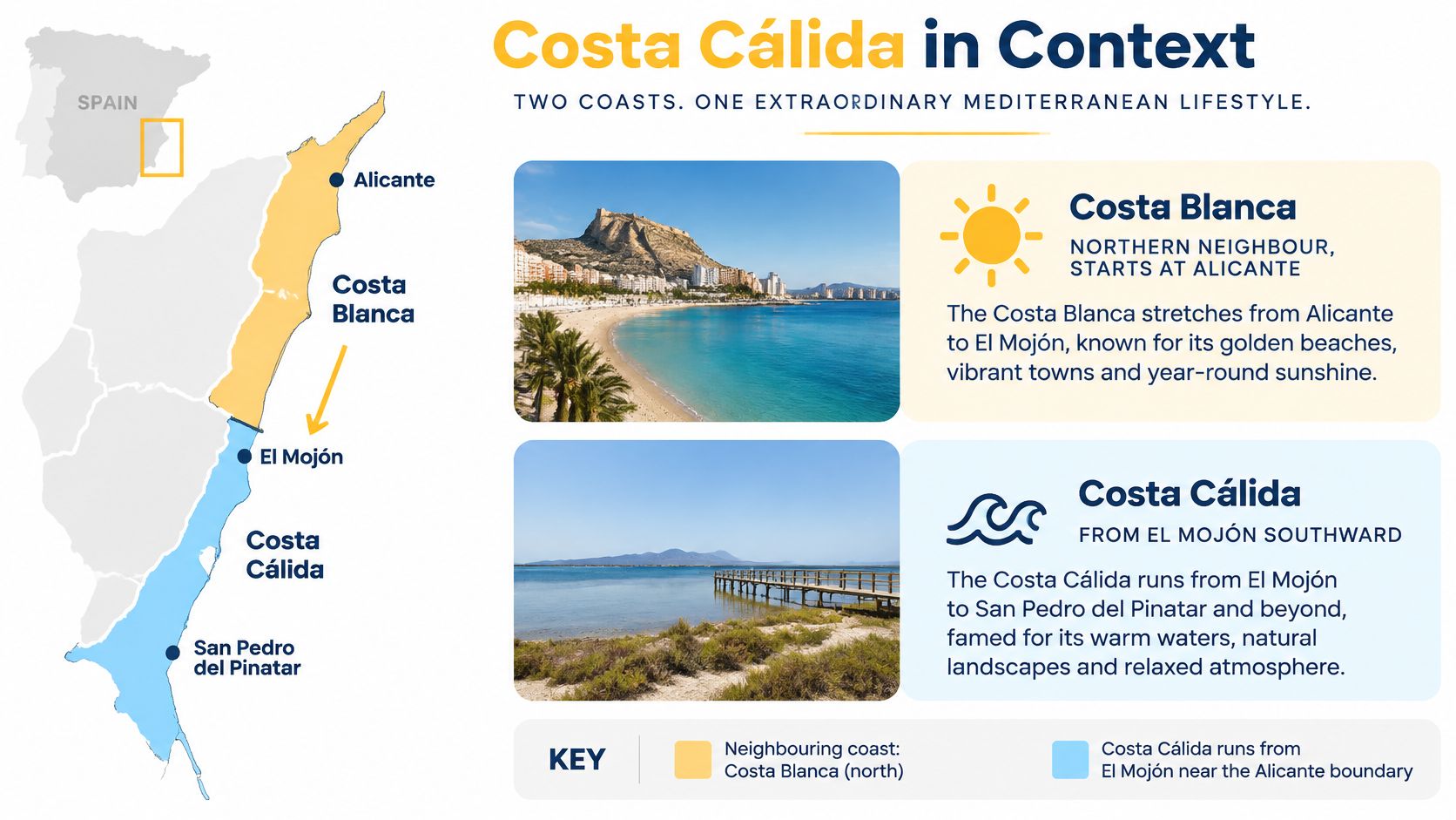
The border itself is invisible on the ground. Drive south past Torrevieja and the urbanisation thins, the salt flats open up, and somewhere around El Mojón and San Pedro del Pinatar you've crossed from Alicante province into Murcia. No sign announces it, no fence marks it, and the beach continues. On a map, though, that transition line matters, because two different regional governments write the planning rules on either side of it.
Practical check: when a listing or guide says "Costa Blanca", confirm whether the town sits inside Alicante province or inside the Region of Murcia. The names blur at the border; the administration doesn't.
Three coasts, three distinct characters. The Costa Blanca has a longer history of northern European settlement and a denser coastal strip around Benidorm and Torrevieja. The Costa Cálida is quieter overall, with a working port city in Cartagena and a lagoon system you won't find further north. The Costa de Almería, beyond Águilas, turns drier and more dramatic.
What the comparison gives you is expectations, not conclusions. Read each coast on its own terms, and treat the boundary as a real administrative line even when the sand suggests otherwise.
Mar Menor and Open Mediterranean Coasts Compared
Two bodies of water, one region. The Mar Menor is a large saltwater lagoon separated from the Mediterranean by La Manga, and official regional tourism material describes it as a warm, shallow lagoon suited to year-round nautical activities, as the Murcia tourism coastal guide sets out. That single sentence explains most of the difference in how these towns live.
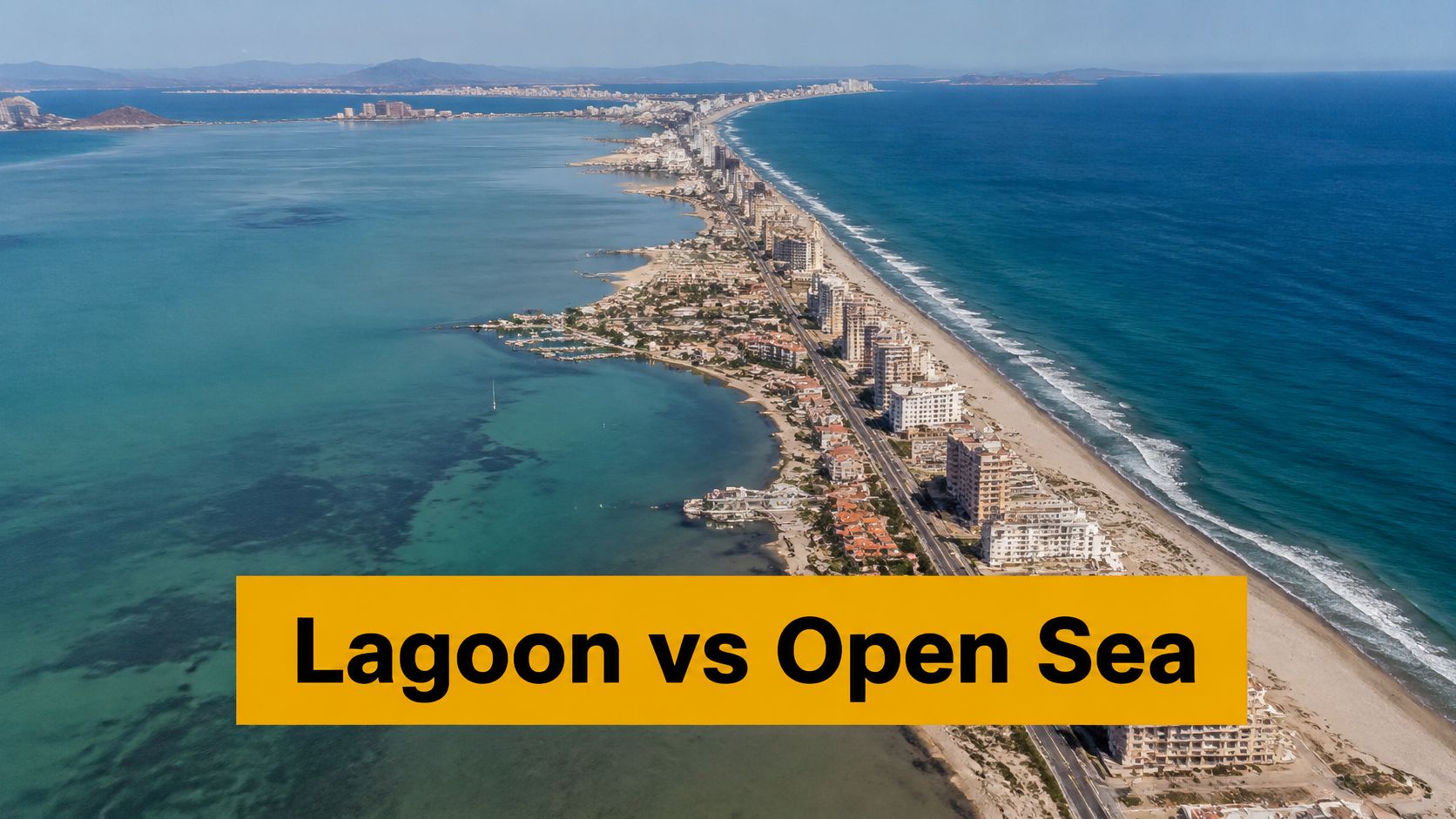
Start with wave exposure. Lagoon frontage sits behind land, so the water stays flat even when the Mediterranean is choppy. Open-sea frontage takes whatever the weather sends, which is why the diving and sailing cultures around Cabo de Palos and Cartagena grew where they did. Then water depth: shallow on the lagoon side, deeper and quicker to drop off on the open coast. Then harbour type, from lagoon marinas built for small craft to the commercial port at Cartagena.
La Manga concentrates the whole problem into one place. It's a narrow strip, not a municipality of its own: official regional tourism material states that La Manga del Mar Menor comprises two localities, Cartagena and San Javier, and gives the strip 44 kilometres of beaches split between the lagoon and the Mediterranean, according to the Murcia sun and beach pages.
Use this as your test on any town description. Lagoon-facing means calm water and shallows. Open-sea means swell and a wider variety of beach types. If a listing names La Manga without saying which side, ask.
The error readers make most often is assuming the two sides are interchangeable because they share a postcode area. They aren't. The same name can deliver a sheltered paddle beach or a surf-facing shore depending on which side of the strip it sits.
Protected Coastline Shown on the Map
At the northern end of the region, the map has a hard boundary that property searches ignore at their peril. The Regional Park of Salinas y Arenales de San Pedro del Pinatar occupies 856 hectares between the municipalities of San Pedro del Pinatar and San Javier and includes six kilometres of Mediterranean coastline, according to the Murcianatural park plan.
It's a wetland of international importance for nesting and resting birds. The scenery inside it reads like a list of everything a coastal map should show: salt ponds, salt pans, reed beds, pine forest, dunes and beaches. The park also contains Las Encañizadas, the natural connection between the Mar Menor and the Mediterranean, where traditional sustainable fishing has been practised.
That last detail is the one worth pausing on. Las Encañizadas is a channel, which means the lagoon and the sea are physically linked at the northern end. The lagoon isn't a sealed pond; it exchanges water with the Mediterranean through a narrow, protected passage, and the fishing that happens there is older than any of the resorts around it.
Reading rule: a protected boundary drawn on the map means the coastline there is not uninterrupted urban development. Check the park's edge before assuming a plot, a reform or an extension is straightforward.
The Mar Menor carries its own planning controls on top of this, and those controls touch renovation and new-build feasibility in ways a map can flag but not settle. Treat map screening as the first pass. Legal review by a qualified local adviser comes second, and this section is background context, not a legal opinion on any specific site.
Which Areas Stay Active Outside Summer
Which coastal areas still feel practical when summer crowds thin out? The Region of Murcia's statistical office defines Costa Cálida tourism through seven municipalities: Águilas, Cartagena, Mazarrón, San Javier, San Pedro del Pinatar, La Unión and Los Alcázares, as recorded in the Murcia regional statistics office data.
The official list is not a simple roll-call of beachfront destinations. It includes La Unión, showing that the definition follows municipal and service boundaries, not just the shoreline. On a map, La Manga and the Mar Menor can look like one continuous holiday area. In practice, access, services, housing and municipal responsibilities vary between them.
Seasonality is another map layer to consider. Hotel demand in May is far higher than in February, so a busy spring visit may give a misleading impression of how active a place feels in winter.
A bright summer photograph tells you little about February. Check which services remain open before treating a coastal spot as active year-round.
For a second home used mainly in July and August, fewer winter services may be acceptable. For a permanent residence, they can shape daily life. Check whether shops, healthcare and restaurants operate through winter, how transport links work outside peak season, and whether the area has year-round residents rather than mainly holiday visitors.
The two waterfronts also help explain why activity differs. The Mar Menor's sheltered shore and the open Mediterranean coast do not function as one uninterrupted resort strip. Compare the specific town and its services, not just its position beside the water.
Holiday appeal and permanent-living infrastructure answer different needs. Decide which matters more before narrowing your map search.
Reaching Each Coastal Area from the Airport
Air access sets the rhythm of every trip you'll make here. The Región de Murcia International Airport is the region's principal air-access reference for international visitors, and Aena's official airport information currently lists nine operated destinations served by five airlines, according to the Aena Murcia airport destinations page.
The detail people miss is location. The airport sits near Corvera, inland from the coastal municipalities. It isn't a beach airport, and a map that drops a plane icon onto the shoreline has already misled you. Place it inland, then measure outward to Cartagena, the Mar Menor shore, San Javier, Mazarrón and Águilas, each of which sits at a different distance and in a different direction.
Distance and direction together give you the transfer picture. The areas closest to Corvera tend to have the shortest transfers, which favours the Mar Menor towns and the Cartagena side. Águilas, at the south-western end near Almería, needs a longer drive. That's not a flaw, just a fact to budget for, especially on arrival days with a late flight.
Routes change, so treat the destination count as time-sensitive and check the current airline schedule before you plan travel around it.
Before you commit to an area: open your own map, confirm the airport's inland position, and trace the actual road route to the town you're considering. The drive you'll repeat dozens of times is worth testing once at the planning stage.
Read the Map Step by Step and Avoid Common Errors
Six steps, in this order, will take you from a blank regional map to a working shortlist.
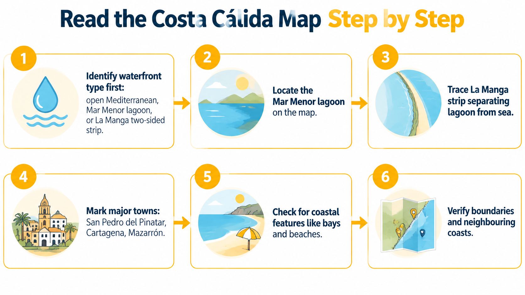
- Fix the waterfront type first. Decide whether you want open Mediterranean, Mar Menor lagoon, or the two-sided La Manga strip. Doing this before anything else prevents the classic mix-up of comparing a lagoon town with an open-sea town as if they were alternatives of the same kind.
- Locate the municipality. Use the seven-municipality tourism definition to see which towns share services and which answer to a different council. Two beaches ten minutes apart can sit in different municipalities with different rules.
- Trace the protected coastline. Mark the Salinas y Arenales park between San Pedro del Pinatar and San Javier, then overlay the Mar Menor planning layers around La Manga, Los Alcázares, San Javier and San Pedro del Pinatar. The regional SIT-Murcia infrastructure publishes Web Map Service layers for the Coastal Spatial Plan, coastal orthophotography and the zones covered by Decree-Law 2/2019 on the protection of the Mar Menor, as listed in the SIT-Murcia thematic WMS catalogue. Those layers tell you where lagoon-related controls may affect renovation, new-build feasibility or land-use interpretation.
- Test seasonal convenience. Apply the demand figures and the year-round services question to each candidate area. A place that empties in November is a different purchase from one that doesn't.
- Check access. Mark the inland airport near Corvera and the main roads, then note which towns need a longer transfer. This step usually reorders the shortlist.
- Shortlist two or three areas. Each one should carry three notes: a waterfront type, a seasonal note and a travel time. If an area can't be described in those three terms, you don't know it well enough yet.
Two errors left over
The first is judging winter appeal from summer photographs. A sunlit marina in August says nothing about whether the supermarket stays open in January.
The second is reading one beach label as the whole coastline. A single pin on a map stands for a stretch of shore with its own exposure, access and rules, and the label rarely captures any of that.
Run the steps in order before your first viewing trip, not after. A map used this way saves you days of driving between areas that were never really candidates.
Shortlist Your Costa Cálida Area Before Searching
Before you open a single listing page, write down three answers. They take five minutes and they'll cut your search area by more than half.
- Waterfront preference: lagoon, open sea, or the La Manga strip with both. This picks your column in the table at the top.
- Timing: year-round living or seasonal use. This decides how much weight winter services carry.
- Access needs: how far you're willing to be from Corvera airport and the main road network, and whether that matters every trip or twice a year.
With those three written down, go back to the reference table and choose two or three areas. Not eight, not five. A shortlist beats a long list because each municipality carries its own services, its own planning rules and its own seasonal pattern, and you can only learn a handful properly.
AP Properties Spain works across the Costa Blanca and the Costa Cálida, and the property search on its site can filter by location, property type, bedrooms, maximum price, sea views, key-ready status and proximity to golf, which is a faster way to test a shortlist against live stock than scrolling through portals. Specific planning questions belong with a qualified local adviser, not with a map alone.
Then take one next action: pick two areas, and check each one against all three of your answers. If an area fails on timing or access, drop it now rather than after three viewings.
A shortlist built this way gives you something a search filter can't: the reason each area made the cut. AP Properties Spain buys and sells new-build and resale property across the Costa Blanca and Costa Cálida, with advisors who work through area guidance, listings, negotiation and legal coordination as one process rather than separate steps. Bring your two chosen areas and the three answers behind them, and we'll match them against current stock, planning constraints and realistic travel times. Start at AP Properties Spain and tell us which waterfront you're after.
Share


